


I last post I mentioned that the topography, Thus the terrain physical form, have a decisive impact on whether your timber garden will suffer from lack of water or if it will thrive and grow as a jungle. But first, a little more basic hydrology: All the water on our sites we do not add artificial water that once fell to the earth as rain or snow. In spring, during snowmelt and spring thaw is often large quantities of water that moves through the landscape, while we often suffer by peasants feared early summer drought later in the year. During the culture period is usually the water supply cut, Before reservoirs in the landscape is filled again by the autumn. For that reason, begins the hydrological year 1 October and ends 30 september.

What drives the movement of water through the landscape is the gravitational force, which pulls the water down from the mountains and hills, by lowland and ultimately to the ocean. Each stream and each A is driven by gravity. On the way stuck it understood a lot of water in the various so-called magazine. It may be lakes, glaciers, mark- and groundwater and plants and animals. A large part of this water never reaches the sea, but evaporates and goes straight back to the atmosphere (and thus becomes a part of the actual evaporation, which I wrote about in first post).
One thing that is very important to know in this context is that most of the water moving through the landscape do not do it in the form of surface water, but in the ground. This has to do with that in Sweden we rarely get very heavy rain at once. Usually the soil can absorb most of the water raining down, and then the rain water to ground water. Sandy soils can absorb, for example, about 50 mm rainfall per hour, moraine 25 mm, garden soil 12,5 mm and heavy clay as low as 5 mm per hour [1]. But even rainfall on 5 mm per hour are rare with us, and runoff occurs, except during snowmelt when large amounts of water are released, no more than a few times a year at most locations in Sweden.
Each spot is thus affected both by the prevailing rainfall patterns and the water that passes by on its way through the countryside. And the more "landscape" located upstream from the place where we grow, the greater is the potentially available water. Therefore, the northern coast suitable for timber gardening than Gotland.
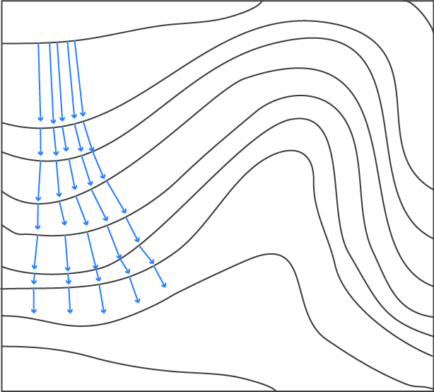
Based on this brief digression on the water cycle, we can distinguish between three different situations in which the water-related conditions. We'll start with the worst place, the one that will suffer from water shortages. The picture below shows a typical map excerpts. The blue arrows show how water moves down the left slope, always perpendicular to the contour lines. The steeper the slope, the faster moving water. It is clearly seen that the arrows are pointing more and more away from each other, which means that the amount of water per unit area decreases. The water spread out in a spray, and vegetation will be completely different than the next working example.
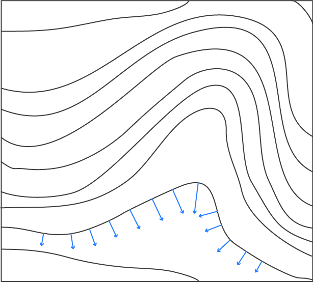
The second picture shows another part of the same landscape, a valley to the right of the dry slope. Here pointing arrows all toward the center of the valley, which means that the amount of water per unit area becomes larger and larger the closer to the mainstream, we will. The water is concentrated in a funnel, and this may well be a stream where the arrows meet. Ground water moves relatively quickly and we can assume that it is well oxygenated. Oxygenated, moving water is perfect for growing really all plants, but in this kind of terrain, it is difficult to grow large scale, so it is found that forest horticulture, especially nut trees who love moving soil water.

The last Typically, the flat ground. Here are accumulated water from the surrounding slopes. What characterizes this kind of place is that ground water velocity decreases considerably and there is often a naturally high water table in these areas. sTATIONARY, shallow groundwater is married for almost all trees and shrubs and in traditional agriculture has solved the problem by draining out the chips to lower the groundwater table permanently and thus allow cultivation.
To look at soil water movement in the bird's eye view is one thing, but it is equally interesting to see how the water moves in cross. More on that in the next post.
References
[1] FAO Corporate Document Repository. 2. Water and Soil Requirements. http://www.fao.org/docrep/u3160e/u3160e04.htm, Retrieved 2017.
Fun to see how you approach the ecological knowledge step by step through their own experience in the field !